But we’re lost on the Westway…
Today after almost three years of build-up the Mayor of London finally released via Transport for London (TfL) plans for the continuation of the part-built East-West Cycle Superhighway along the Westway from Paddington to Acton. This will complete the consultation phase of the key piece of the Mayor of London’s Cycle Vision as launched in March 2013. In the cycle vision we were told by the Mayor (or rather his cycle commissioner, Andrew Gilligan):
“We will open a fast, segregated cycle superhighway – a true ‘Crossrail for the bike’ – stretching at least 15 miles west-east through the heart of London, from the western suburbs to Canary Wharf and Barking. We believe that it will be the longest continuous largely-segregated urban cycle route in Europe.”
and
“The route will follow existing, but improved, segregated tracks alongside part of the surface stretch of the A40. At Wood Lane, White City […] My plan is that it will then join a bi-directional cycle track created by removing one of the six traffic lanes from the Westway flyover.”
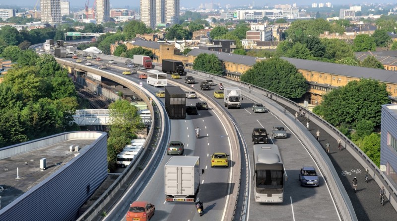
So today’s announcement is hardly a surprise and has been well telegraphed for some time. Yet as with the earlier consultation on the main section of this superhighway, concerns today have largely focussed on the elements TfL have provided visualisations for. This means a lot of discussion today about the principles of riding on a viaduct with heavy, fast-moving traffic nearby. Spot the differences from an earlier consultation image (top) and today’s (bottom).
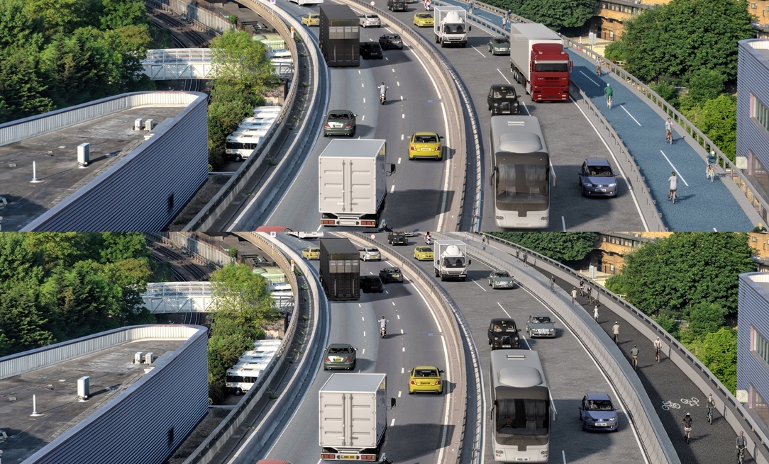
Blue has become black, a truck has become a car and most importantly the barrier between the cycleway and the rest of the Westway is now a joint barrier and glass wall reaching 1.8m in height beside the cycleway. This combination is seen in successful separation of cycleway and fast motor traffic on the continent, and I was one of those who suggested the need for it in the consultation process at an earlier stage.
Sounds like Westway cycle route will have glass panelling like this Nijmegen bridge. pic.twitter.com/WIDAdqiFXd
— Mark Treasure (@AsEasyAsRiding) February 8, 2016
There is also a cross-section and other details in the relevant section of the consultation:

I think with these design details questions about an elevated section can focus on other issues such as lighting and CCTV along with the gradient of approaches. Questions we should just ask about now and consider before submitting responses to the consultation. There are questions to ask about not being able to link from this route whilst it passes through Kensington and Chelsea’s borough, but those questions should really be directed at Kensington and Chelsea who refused any segregation on their roads. They claim they are offering “quietways for people put off cycling by sharing the road with heavy vehicles. We will have five such quietways in the borough by close of 2016.” Here’s a map of them with the Westway superhighway overlaid at the top and the cancelled route of Superhighway 9 below: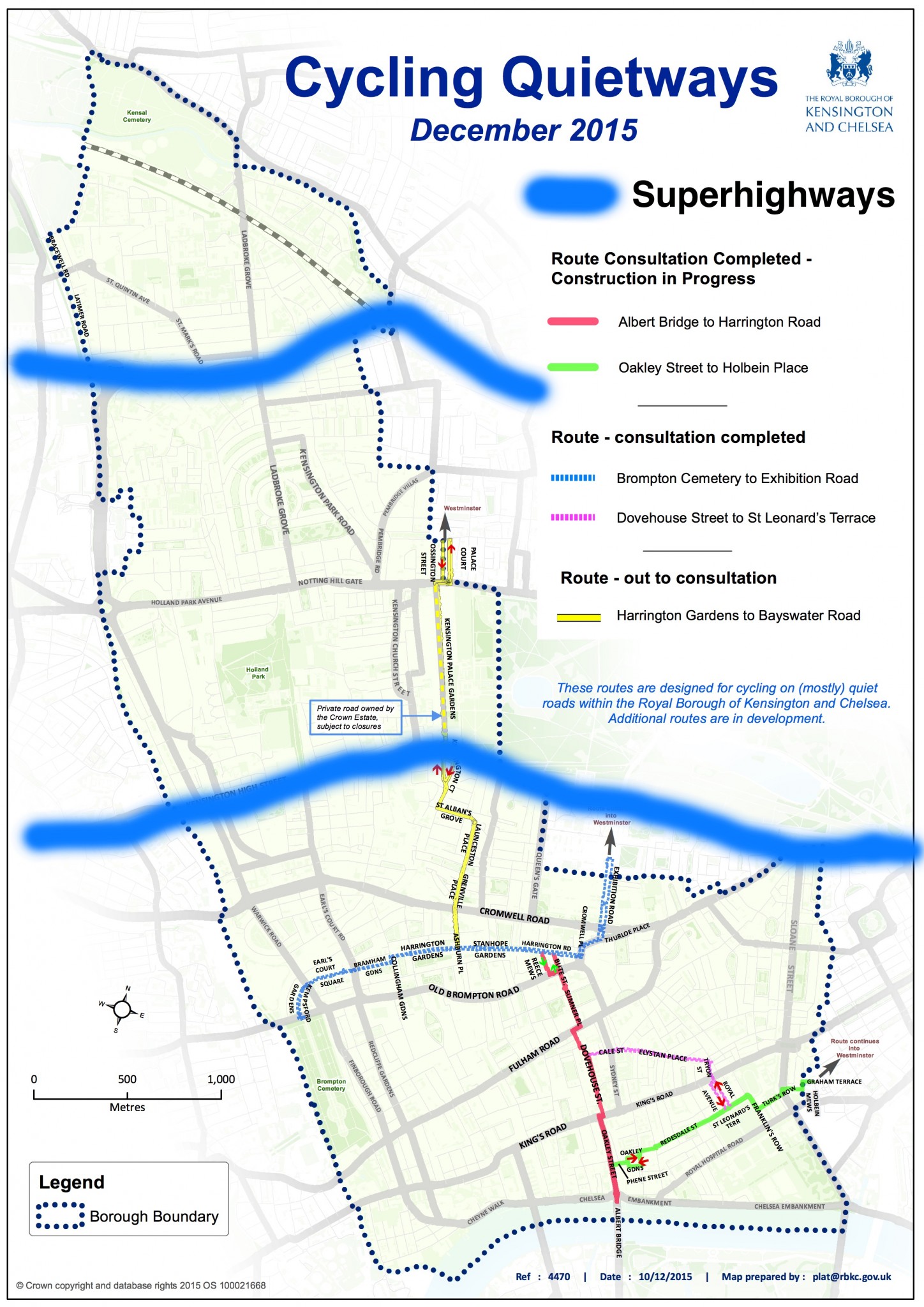
The quietways being built by Kensington and Chelsea really don’t offer an alternative to the Westway, or indeed an alternative route from east to west to replace that of Superhighway 9 either. Let us think then look at this map thinking about which other routes we actually need. Some assert that there must be some way of making a route along the Westway at ground level and not use the elevated section, however as this would cross several busy streets and go through a few markets, sports complexes and so on I’d want to see detail. However, it is true that a local network is necessary towards the north of Kensington and Chelsea and Westminster as well. The London Cycle Design Standards as adopted under the Cycle Vision seeks a route density equal to 400m grid squares. The conclusion this basically drives you towards is that yes, a route on the Westway’s elevated section won’t serve those underneath it if there’s no links. But, and it’s an important but, without that elevated section there would be no route built to the standard of the Cycle Vision (dealing with the sharing with heavy vehicles even Kensington and Chelsea refer to) that traversed the borough from East to West.
On this basis I’m quite convinced that the choice of the Westway for the superhighway is a relatively natural combination of the lack of availability to TfL of other routes and the need to provide a high-capacity route into a growing area in West London. The junction where the superhighway will land is a good spot from which to then reach White City, Park Royal and Old Oak Common, all of which are currently planned to see huge developments and even new stations for both Crossrail and HS2. The junction proposed is reasonably good, but it would be better if it was clear that it would be linked to safe routes proceeding north and south. Instead all melts to paint in just a few short metres.

On a related note at the time of the Cycle Vision we were promised that “Extensive connecting routes will be opened to link the new route to nearby town centres, such as Acton, Ealing, Wembley, Westfield Shepherd’s Bush and Canning Town.” These have become merely the “potential for future high-quality link routes to Shepherds Bush, Harlesden, Wembley, Acton and Ealing town centres” in the consulted scheme. This is a big concern. Without a network of strong links this superhighway risks seeing slower than expected growth in use. This should all be picked up in responses and the case made for a proper dense cycle network supported by funding and changes associated with nearby developments in some cases.
We should also focus upon the route along the A40 for the section that is not elevated. It seems odd to have barriers and glass walls to protect cycles from nearby traffic on the elevated section and yet when these same people on bikes emerge onto the pavement (shared use, no less) to head for Acton they merely get to ride on a broad pavement separated by the drop of a kerb from fast (40-50mph) multi-lane traffic.
 This seems rather like the least change they could offer. And when I rode the existing route a couple of years ago as an experiment cycling to Ealing it felt like the least appealing route I’d tried in some time. On the other hand, it does go near to a range of shops, entertainment venues and other destinations I simply never even considered reaching. Those destinations aren’t going to disappear so why shouldn’t they have a cycle route provided? It just feels a lot harder to believe that somehow there’s no scope for using the rather broad roadspace available to make cycling better and more distinct from pedestrian space in this corridor.
Anyway, that’s my thoughts from having flicked over this later section of the East-West Superhighway. The Westway’s elevated section is not a natural choice, but I do think given the right context that it’s an understandable one, and it can be a useful and meaningful link in a wider network of similarly high quality routes. Therefore I think a good chunk of the responses we make should focus on that wider network and how this superhighway should be linking into it. It may be rather easy for the pavement section along the A40 to look reasonable now, but what if people using it need to reach the pavement on the north side?
 Meanwhile, I of course have moved from Hammersmith which had the cancelled Superhighway 9 reaching it to Forest Hill, which should have been reached by the cancelled Superhighway 6. Not the best of luck, but I do get to use the already built sections of the North-South superhighway and value them very much. Which leads me to my final thought… We shouldn’t be torn between treasuring the sections of cycleway that we are able to get built and arguing for them to be of the best quality, but we need to articulate in a way that makes plain to even our opponents that we’re still seeing change on just a handful of roads. Meanwhile maybe I should try and find a flatshare close to the Westway and a winch…
You have until midnight on Sunday 20th March to support these proposals. I endorse the recommended response from the London Cycle Campaign, which you may wish to refer to.
Great analysis. I’m very disappointed that, west of Shepherd’s Bush, the proposals pretty much boil down to “you can now cycle on the pavement”.
I regularly use the segregated section near North Acton but it’s far too short and still does not feel safe enough – especially as there was an accident last year in which a car had clearly left the westbound carriageway, crossing the segregated cycle lane, before hitting a street lamp. Aside from the kerb, there is zero protection for cyclists. I would like to see some armco barrier at least.
Also, the links from the superhighway to the surroundings will limit the take-up of the scheme: there are 5 stations within a couple of minutes’ cycle from this stretch of the A40, yet none of them is connected to the A40 by a proper cycle route, making multimodal travel unappealing.